|
|
| Line 13: |
Line 13: |
| {|class="wikitable sortable" | | {|class="wikitable sortable" |
| !crossesElement/@type | | !crossesElement/@type |
| !valid parent | | !Valid parent |
| !real world example | | !Real world example |
| !comment | | !Explanation |
| | !Comment |
| |- | | |- |
| |railway | | |railway |
| Line 24: |
Line 25: |
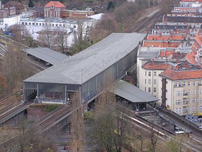
| File:Bahnhof Berlin-Schoeneberg.jpg |Axel Mauruszat https://commons.wikimedia.org/wiki/User:Axel.Mauruszat, Attribution, via Wikimedia Commons https://commons.wikimedia.org/wiki/File:Bahnhof_Berlin-Schoeneberg.jpg | | File:Bahnhof Berlin-Schoeneberg.jpg |Axel Mauruszat https://commons.wikimedia.org/wiki/User:Axel.Mauruszat, Attribution, via Wikimedia Commons https://commons.wikimedia.org/wiki/File:Bahnhof_Berlin-Schoeneberg.jpg |
| </gallery> | | </gallery> |
| | | |
| | | | | |
| |- | | |- |
| Line 33: |
Line 35: |
| </gallery> | | </gallery> |
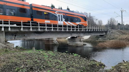
| |because river is UNDER the railway BRIDGE | | |because river is UNDER the railway BRIDGE |
| | | |
| |- | | |- |
| |road | | |road |
| |{{IS:Tag|underCrossing}} | | |{{IS:Tag|underCrossing}} |
| |Srđan Popović, CC BY-SA 4.0 <https://creativecommons.org/licenses/by-sa/4.0>, via Wikimedia Commons - https://commons.wikimedia.org/wiki/File:Auto_put_%C5%BEelezni%C4%8Dki_vijadukt.jpg | | | |
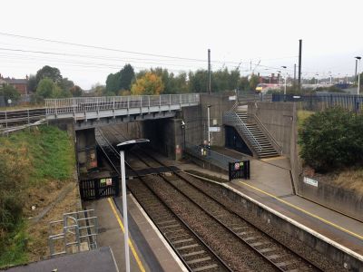
| Hampson Street Railway Bridge by David Dixon, CC BY-SA 2.0 <https://creativecommons.org/licenses/by-sa/2.0>, via Wikimedia Commons - https://commons.wikimedia.org/wiki/File:Hampson_Street_Railway_Bridge_-_geograph.org.uk_-_5294877.jpg
| |
| |because road is UNDER the railway BRIDGE | | |because road is UNDER the railway BRIDGE |
| | |see also |
| | 1) {{external|https://creativecommons.org/licenses/by-sa/2.0|CC BY-SA 2.0}} {{external|https://commons.wikimedia.org/wiki/File:Hampson_Street_Railway_Bridge_-_geograph.org.uk_-_5294877.jpg|Hampson Street Railway Bridge}} by David Dixon {{external|https://commons.wikimedia.org/wiki/User:GeographBot|GeographBot}} via Wikimedia Commons |
| | 2) {{external|https://creativecommons.org/licenses/by-sa/4.0|CC BY-SA 4.0}} {{external|https://commons.wikimedia.org/wiki/User:Kos93|Kos93}} {{external|https://commons.wikimedia.org/wiki/File:Auto_put_%C5%BEelezni%C4%8Dki_vijadukt.jpg|Auto put železnički vijadukt.jpg}} by Srđan Popović via Wikimedia Commons |
| |- | | |- |
| |road | | |road |
| |{{IS:Tag|overCrossing}} | | |{{IS:Tag|overCrossing}} |
| | | | | |
|
| |
| <gallery widths=700px heights=300px> | | <gallery widths=700px heights=300px> |
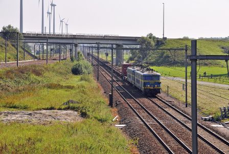
| File:Dudzele Junction R02.jpg|Marc Ryckaert (MJJR) https://commons.wikimedia.org/wiki/User:MJJR, CC BY 3.0 <https://creativecommons.org/licenses/by/3.0>, via Wikimedia Commons - https://commons.wikimedia.org/wiki/File:Dudzele_Junction_R02.jpg | | File:Dudzele Junction R02.jpg|Marc Ryckaert (MJJR) https://commons.wikimedia.org/wiki/User:MJJR, CC BY 3.0 <https://creativecommons.org/licenses/by/3.0>, via Wikimedia Commons - https://commons.wikimedia.org/wiki/File:Dudzele_Junction_R02.jpg |
| </gallery> | | </gallery> |
|
| |
| Falk2, CC BY-SA 4.0 <https://creativecommons.org/licenses/by-sa/4.0>, via Wikimedia Commons - https://commons.wikimedia.org/wiki/File:C1.23a_Bf_Lr,_Stw_4.jpg
| |
|
| |
| |because road BRIDGE is OVER the railway | | |because road BRIDGE is OVER the railway |
| | |see also {{external|https://creativecommons.org/licenses/by-sa/4.0|CC BY-SA 4.0}} {{external|https://commons.wikimedia.org/wiki/User:Falk2|Falk2}} {{external|https://commons.wikimedia.org/wiki/File:C1.23a_Bf_Lr,_Stw_4.jpg|C1.23a Bf Lr, Stw 4.jpg}} via Wikimedia Commons |
| |- | | |- |
| |cycleway | | |cycleway |
| |{{IS:Tag|underCrossing}} | | |{{IS:Tag|underCrossing}} |
| |Railway bridge at Thackley by Stephen Craven, CC BY-SA 2.0 <https://creativecommons.org/licenses/by-sa/2.0>, via Wikimedia Commons - https://commons.wikimedia.org/wiki/File:Railway_bridge_at_Thackley_-_geograph.org.uk_-_5429648.jpg | | | |
| |because cycleway is UNDER the railway BRIDGE | | |because cycleway is UNDER the railway BRIDGE |
| | | see also {{external|https://creativecommons.org/licenses/by-sa/2.0|CC BY-SA 2.0}} {{external|https://commons.wikimedia.org/wiki/User:GeographBot|GeographBot}} {{external|https://commons.wikimedia.org/wiki/File:Railway_bridge_at_Thackley_-_geograph.org.uk_-_5429648.jpg|Railway bridge at Thackley}} by Stephen Craven via Wikimedia Commons |
| |- | | |- |
| |road | | |road |
| |{{IS:Tag|overCrossing}} | | |{{IS:Tag|overCrossing}} |
| |The railway entering Ryde Tunnel by Steve Daniels, CC BY-SA 2.0 <https://creativecommons.org/licenses/by-sa/2.0>, via Wikimedia Commons - https://commons.wikimedia.org/wiki/File:The_railway_entering_Ryde_Tunnel_-_geograph.org.uk_-_5822454.jpg | | | |
| |because road is OVER the railway TUNNEL | | |because road is OVER the railway TUNNEL |
| | |see also {{external|https://creativecommons.org/licenses/by-sa/2.0|CC BY-SA 2.0}} {{external|https://commons.wikimedia.org/wiki/User:GeographBot|GeographBot}} {{external|https://commons.wikimedia.org/wiki/File:The_railway_entering_Ryde_Tunnel_-_geograph.org.uk_-_5822454.jpg|The railway entering Ryde Tunnel}} by Steve Daniels via Wikimedia Commons |
| |- | | |- |
| |footway | | |footway |
| |{{IS:Tag|overCrossing}} | | |{{IS:Tag|overCrossing}} |
| |Ludlow railway station and tunnel by Gareth James, CC BY-SA 2.0 <https://creativecommons.org/licenses/by-sa/2.0>, via Wikimedia Commons - https://commons.wikimedia.org/wiki/File:Ludlow_railway_station_and_tunnel_-_geograph.org.uk_-_4088041.jpg | | | |
| |because footway is OVER the railway TUNNEL | | |because footway is OVER the railway TUNNEL |
| | |see also {{external|https://creativecommons.org/licenses/by-sa/2.0|CC BY-SA 2.0}} {{external|https://commons.wikimedia.org/wiki/User:GeographBot|GeographBot}} {{external|https://commons.wikimedia.org/wiki/File:Ludlow_railway_station_and_tunnel_-_geograph.org.uk_-_4088041.jpg|Ludlow railway station and tunnel}} by Gareth James via Wikimedia Commons |
| |- | | |- |
| |footway | | |footway |
| |{{IS:Tag|overCrossing}} | | |{{IS:Tag|overCrossing}} |
| |Severn Tunnel Junction railway station footbridge by Jaggery, CC BY-SA 2.0 <https://creativecommons.org/licenses/by-sa/2.0>, via Wikimedia Commons - https://commons.wikimedia.org/wiki/File:Severn_Tunnel_Junction_railway_station_footbridge_-_geograph.org.uk_-_3757583.jpg | | | |
| |because footway BRIDGE is OVER the railway | | |because footway BRIDGE is OVER the railway |
| | |see also {{external|https://creativecommons.org/licenses/by-sa/2.0|CC BY-SA 2.0}} {{external|https://commons.wikimedia.org/wiki/User:GeographBot|GeographBot}} {{external|https://commons.wikimedia.org/wiki/File:Severn_Tunnel_Junction_railway_station_footbridge_-_geograph.org.uk_-_3757583.jpg|Severn Tunnel Junction railway station footbridge}} by Jaggery via Wikimedia Commons |
| |- | | |- |
| |} | | |} |


